by Winding Pathways | Nov 13, 2025 | Travel/Columns, Wonderment
Chance Encounter Leads to Wall Mural Tours*

Zing is blessed with tetrachomacy.
Rich had a fleeting encounter with a muralist in October that inspired us to explore mural trails in the Cedar Rapids area. While we have passed by and noted many on our travels and around town, we had never sought them out.
Here’s how our mural trail tours started. Every once in a while, Rich visits Fia’s Finds, a consignment store on First Avenue SE, in hopes of finding a replacement for his favored vintage coffee cup that broke a few years back. No luck on the coffee cup but he had a delightful brief chat with Zing, a young woman creating a colorful mural on the store’s outer wall.That got us thinking more about murals.
Paducah, Kentucky’s Wall Legacy

Repairing mural.
Actually, we’ve long noted wall murals. But this August our interest was piqued while walking along Paducah, Kentucky’s flood wall. Crafted on the long wall were murals depicting the city’s rich history. They were magnificent art that told a story. And, they are maintained. An artist was diligently working in the summer’s heat to refresh one of the panels. He explained that is part of his job thanks to long term funding, is to keep the murals in good condition. After that, we started paying more attention to murals.
Coffee Cup Connection
Yields Invitation
Back to Fia’s Finds. In early November owner, Sophia Joseph, invited us to a reception honoring Zing (Phelps), who’ll continue the mural when the weather warms next spring.
“I’m actually a tattoo artist. This is my first mural,” Zing told us with pride and enthusiasm, evidence of her craft poking through her torn jean pants. Her comment gave us a perspective. A mural is sort of a big tattoo on a wall. When we mentioned this, she responded, “Yeah, but a mural doesn’t wiggle when you work on it!”

Honored at a reception.
When Zing’s family joined the reception stories began to flow. Her mom noted that as a kid she used markers to draw. On everything – including walls! So, her mom bought her real sets of art supplies. COVID-19 restricted so much but also opened doors. Zing took formal lessons through the visual arts division, a hybrid middle school, at the Figge Museum in Davenport, Iowa. She got more excited about drawing and tattoo work and now works at Wildside Tattoo.
She connected with Fia’s Finds owner, Sophia Joseph, after Joseph posted on Cedar Rapids Support Local seeking a wall artist. “It was the first time I ever asked permission to paint on a wall,” Zing quipped. Her mom smiled in agreement.
Wall Murals Everywhere
In our travels we have seen wall art murals popping up. In 2013 we visited the Freak Alley Gallery in Boise, Idaho. A cool experience watching artists transform an alleyway into an outdoor art gallery. Yearly, the murals are changed. Nationwide, transformative art on buildings now is the rage. And, such spectacular examples abound.
-

-
Machines help.
-

-
Edgy Artist
-

-
From dreamy to edgy Freak Alley draws in various artist.
-

-
Message
Dubuque, Iowa, has wonderful street art and wall murals downtown that we admire when we visit.
-

-
Handsome mural
-

-
Fun!
What’s New is Old

maintanence is important.
But wall murals are not a new concept. Decades ago, businesses used wall art to advertise their products like soft drinks and smokes. A local example that could use love is the Firestone garage at 10th St. and Second Ave SE. On the back side of the building next to PCI II is a faded image of the Firestone logo. Zing may just be the talented artist who could help revive this iconic wall art. She listens to clients, is creative and uses her gift of tetrachormacy to full advantage.
Mural Tour
Since we met Zing, we have taken tours of wall art in and near Cedar Rapids.
Highway 30 and Mt. Vernon
Out toward and in Mt. Vernon are some dandy barn murals. Our first stop was at the Big Apple Orchard on Hwy 30 near Mount Vernon. The barn sports a big mural of the Statue of Liberty with a twist. She holds an apple in her upthrust hand. Just east of Palisades State Park on the south side of Hwy 30 is the iconic American Gothic painting and a realistic buffalo prairie scene. A variation of wall murals is barn quilts that dot our landscapes and we have featured in the Cedar Rapids Gazette.
The town of Mt. Vernon is well know for its spring Chalk the Walk event where artists design and color in murals on the blocked-off main street.
-

-
2200+ trees and 20+ varieties.
-

-
Maintaing wall art.
Cedar Rapids
From there we visited more urban wall murals in Cedar Rapids’ Czech Village, New Bohemia, Kingston Yard, and along First and Second Avenues. Another day we stopped by Shores in the Mount Mercy University area and enjoyed two murals. We are eager to check out the new one in the Ground Transportation Center and see about a canvas one in the Alliant Tower.
-

-
Fix Salon wall.
-

-
Look up!
-

-
Beautifully renovated
-

-
Dancer captures flow of dancing mural. Photo Credit Kliff McDowell.
They’re all colorful and fun. All tell a story. A great example is in Cedar Rapids’ Greene Square Park. Painted on an adjacent parking garage is a mural celebrating the Great America Rail Trail. It overlooks a section of the trail that will eventually stretch from coast to coast. Rich, and a friend, have bicycled portions of this trail in Nebraska.
-

-
Welcome to Czech Village.
-

-
American Discovery Trail.
-

-
Edgy mural
We have visited in a small sample of the street art/wall murals in our town, and will visit more over the winter months. While the murals are fresh and vibrant now, time takes its toll. So, we do hope businesses and street artists will maintain these unique designs that add vibrancy to any town or rural barn.
How to Find Murals/Wall Art
Murals are fun. We keep on the lookout for them and encourage you to do the same.
Want help finding them? Types of sources to help: Visit the website of the town you are interested in and find street art/wall murals/wall art examples. Locally, Murals & More is a great site to check out. The site streetartcities.com is a start but does not show all. Facebook is a source to check out, too.
We are happy to learn more about these incredible works of art and meet an artist. We will try to connect with other artists over time. Bravo to the artists, partners and sponsors who brighten up our towns and the landscapes.
- While we know there are differences, we use the terms wall art, wall murals, street art interchangeably. While each artist defines differently, the idea is they all creatively tell a story.
by Winding Pathways | Apr 17, 2025 | Geology/Weather, Nature, Travel/Columns
Quincy Warmth
After a short walk through deep snow in the bitter cold, we entered a dimly lit tunnel. As we stepped into Quincy Mine’s long tunnel we were surrounded by warmth. Well, the warmth was relative. Outside it was below zero but inside the tunnel was a balmy 43 degrees.
We visited Quincy Mine in Michigan’s Keweenaw Peninsula in frigid February, but if we had been there on a blistering hot August day the mine’s interior temperature would be a delightfully cool 43 degrees. It’s always that temperature in that tunnel deep underground.
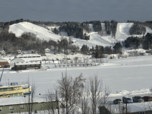
No matter the season, the Keweenaw Peninsula is a fun place to visit. It juts upward into Lake Superior. Lake effect snow piles deeply each winter, but in summer the Lake sends cool breezes inland.
“We Do Winter Well”
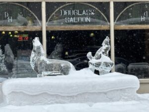
This claim by Visit Keweenaw advocates is no exaggeration. Residents navigate steep, snowy streets with aplomb. Some travel by snowmobiles to work, take a short spin during lunch breaks, and motor on home after work. They dress warmly and relish the cold. The area welcomes winter visitors who enjoy downhill and cross-country skiing, snowshoeing, snowmobiling, shopping, and meals of grilled lake whitefish and locally made pasties. More about them later. Broom and ice hockey regionally and at the Michigan Technological University draw in families by the dozens. The Huskies, sometimes known as the “Stick Huskies” – think hockey – compete, creating fabulous ice sculptures that dot the campus and area.
-
-
Trail groomers started before dawn to groom trils.
-
-
ice sculptures dot the town and campus.
-
-
BoHo is an ungroomed Black Diamond ski area.
Shopping and dining are equally fun in summer, and warmer weather offers boating, swimming, fishing, and sightseeing. During warm months, visitors can book a ride on boats taking them to the distant Isle Royale National Park.
What and Where Is the Keweenaw?
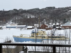
The Keweenaw is actually a peninsula on a peninsula. It’s attached to the relatively wild Upper Peninsula, but interestingly it’s no longer a peninsula at all. Originally a natural inlet extended most of the way across the peninsula’s base. To facilitate shipping, land was removed, extending the inlet into a canal and making the Keweenaw an island. Today the main towns of Houghton and Hancock face each other across the Portage Canal and are separated by one of the world’s largest lift bridges. In summer, dozens of boats motor by, including some large ones.
Copper Country
For us touring Quincy Mine was a visit highlight. For nearly a century it produced thousands of tons of copper that helped America electrify. Quincy is only one of several that once operated in the area but they all were abandoned when less expensive, open pit mining got established in Utah.
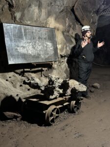
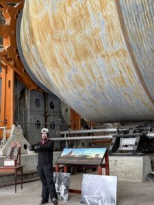
Today Quincy Mine welcomes people to tour its towering surface features that pulled ore up from upwards of 9,000 feet underground. Down that far, the temperatures were blistering 80+ degrees. It was amazing, but we were more fascinated deep down in a mine tunnel when our guide, Clayton Gomez, stopped our small group and doused the electric lights, leaving only one candle to illuminate the vast darkness. “This is how much light miners had as they used muscles to drill into the rock.”
“They’d then stuff blasting power into the hole and set it off. Afterward they loaded the loose stone in carts and pushed it to a shaft where a lift carried it to the surface. It was dangerous and hard work. They earned $2 for a 10-hour shift,” he added. Some of us tried to muscle the heavy cart to little avail.
Initially, the demand was for highly skilled workers in teams of three. One held an iron bar, two alternated hitting the end. In between the one holding the bar, turned it slightly so it would not lodge in the rock. At best this would be dangerous. Done by candle light, required cooperation and skills. Mining innovations changed that. Men worked alone so if an accident happened, they might not be found for hours.
Clayton ended our tour with this thought: “Holes in the ground all we have left to tell the story.” But, he pointed out, copper remains such an important part of our lives. Computers, cars, cell phones.
-
-
Clayton and mine shaft diagram.
-
-
Mine shaft drum.
-
-
Canal. Park Service Boat. Ski run. Quincy Mine Shaft on far hill.
Who Were the Early Settlers and Miners?
The workers, immigrants from the Cornish region, were small, tough, wiry. In the paternalist setting where they received housing and a few amenities, if one got injured or killed, the family was forced to move. After a sweat-soaking shift, the men would change into clothes and step into the sub-freezing weather and trundle home. Only to repeat the process the next day.
Other immigrants from northern Europe arrived and took to the cold, snowy climate. Today skiing and ski jumping are hallmarks of the Nordic heritage. Evidence of the Daughters of Italy, Sons of Norway, Canadian, Finnish and Cornish ancestry highlight the area.
Although mining is now long gone, a delicious traditional food remains. A meat and vegetable pie called a pasty is tasty, nutritious, and portable. (Say the word with a short “a” so as not to confuse with an accoutrement of pole dancers.) Miners would bring this traditional Cornish meal with them as they descended into the pit and enjoy it for lunch.
Many local stores and cafes now sell pasties and we ate several during our stay.
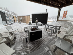
We also enjoyed taking a sauna at Takka Saunas on a frigid day. After sitting in a steamy small sauna building, we dashed out. Marion did the traditional Finnish tradition of laying down in the snow making a snow angel. Rich only stood barefoot in the snow. A sauna part of Finnish culture is fun in any season.
-
-
Amenities abound
-

-
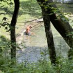
Roll in the snow or plunge into cold water.
Keweenaw Mountain Lodge
Dark sky and slow travel haven.
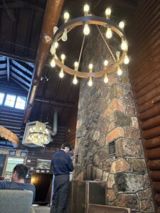
Part of our adventure was finding respite at the Keweenaw Mountain Lodge. Some in our group snowshoed. Others lounged in the rustic ambiance. Adjusting to “slow travel” and learning more about the dark sky options. As the lodge owner stated, “We lean into what is authentic and unique.” Heated cabins and groomed trails beckoned. The chef creates delicious picnic baskets and the Tasting Post features a “slow dining” experience. On clear nights the aurora is spectacular.
Jibba Jabba
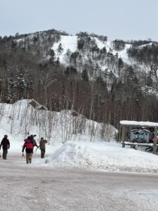
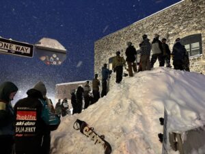
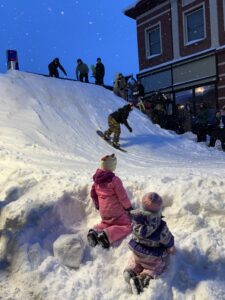
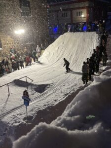
We went to the Keweenaw for the annual Jibba Jabba Railjam. Dozens of young competitors climbed the manufactured hill in downtown Houghton and took turns sluicing down the steep slope, riding rails, swooshing through the tunnel, and spinning to a stop in front of hundreds of enthusiastic spectators. For days ahead, city crews had hauled in and packed snow at just the right angle on one of the steep streets that are hallmarks of Houghton. The result? Fast speed and thrilling rides down the course.
-
-
Snowy wait
-
-
Excitement
-
-
Snowy event
Getting There
Five hundred miles north and slightly East is the thumb of the Keweenaw that juts into Lake Superior. Houghton, MI, is Eastern time so we lost an hour. We took two days going, stopping to walk a special labyrinth in Westfield, WI, and overnight at Rhinelander, taking in the Hodag Hunt. These mythological creatures frequent the town and purportedly the nearby forests. We did encounter several in town, which was fun. Eagle River is worth a stop with a terrific coffee shop and amazing annual ice sculptures.
-

-
The Labyrinth we built as Andy’s Memorial.
-

-
Special labyrinth
After two hours of snowy and scary driving we found clear pavement. Good thing we have advances in car technology and road safety. We stayed on our side of the road because of the center and side rumble strips. No “good ‘ole days” for us. We prefer safe cars and roadways.
We drove back in an easy day as we gained an hour.
-

-
Welcome!
-
-
Hodag hunt
-

-
A beaten path to the visitor center Hodag.
For information on what to do at the Keweenaw and where to stay check out Visit Keweenaw.
We were there during winter’s icy grip but a future visit during summer’s warmth is in our plans.
by Winding Pathways | Jan 2, 2025 | Travel/Columns
Features: 2020 – 2024
2024
(For a list of features go to https://www.thegazette.com/marion-and-rich-patterson/)
For related articles click here.
November 10, 2024. Riding the (t)Rails. (in print copy and Green Gazette)
November 3, 2024. Land of the Dawn.
October 23, 2024. Getting the Lead Out.
August 4, 2024. Washington’s Tri-Cities Region….
July 30, 2024. How Three Iowa Lands Became Home to Restored Prairie. Feature by Bailey Chichon about our work in restoration.
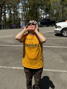
June 9, 2024. Heading South to View the Eclipse….
April 7, 2024. Trave: Wild Winter Wonderland (Alaska in winter)
January 28, 2024. Wandering Pennsylvania’s Wilds
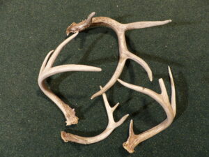
January 15, 2024. Shed Hunting Season
-
-
Safe viewing
-
-
Highlight of a unique trip.
-
2023 – 2022
December 10, 2023. Breathtaking Views (firetowers)
September 10, 2023. Peaceful Prairie (Grasslands of Saskatchewan, CAN)
August 5, 2023. Fly Fishing. (no link to date. Available Green Gazette)
July 16, 2023. Intriguing Riddles From the Hopewell Culture.
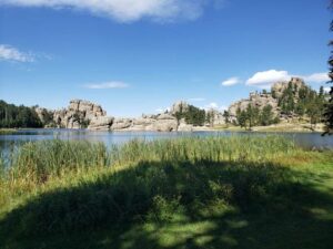
May 29, 2023. Head for The Hills. (Black Hills off Season)
May 21, 2023. Moving Heaven and Earth. (Earth Moving Legacy Museum)
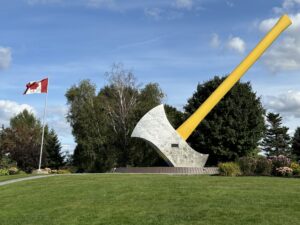
May 5, 2023. Ax Throwing: a Fun Historic Skill.
April 2, 2023. Agritourism Attraction. (Fair Oaks Farms)
March 5, 2023. Seeking Independence. (Truman Presidential Library)
February 3, 2023. A Gem in Pennsylvania’s Laurel Highlands.
January 6, 2023. Ike’s Town. Abilene, Kansas & Western History.
December 4, 2022. Trap Shooting.
September 6, 2022. Riding the Rails (Alaska by Train)
July 17, 2022. Backyard Adventures. (No link to date)
July 11, 2022. Casper, WY, Gateway to the West.
May 12, 2022. Hobo Convention.
May 8, 2022. Splish Splash! Whitewater Kayaking in Iowa. (No link to date)
April 22, 2022. Finding America On Roadways East.
April 13, 2022. Muscle Over motor When Boating.
March 21, 2022. Rockhounding.
January 30, 2022. Backpacking Bonus. (8B of GZ. No link to date) Available Green Gazette.
January 24, 2022. Distinctive Religious Structures.
January 16, 2022. Hiking Wild Areas. (no link to date) Available Green Gazette.
-
-
A favorite spot in the Black Hills
-

-
View of an iconic Cedar Rapids church.
-

-
A grand time in Britt, Iowa
2021-2020
December, 2021. Country Schools. (no link to date) Available Green Gazette
November 15, 2021. Making a (Mini) Pitch for Soccer.
October 6, 2021. A visit with Midwest’s Pioneering Authors.
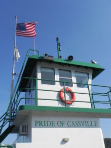
September 8, 2021. Taking a Slow Boat to Cassville.
September 6, 2021. Camping in Iowa’s Trout Country & Decorah’s Celebrities.
August 4, 2021. Parking While Headed East. And Solar Panels at Peoples.
June 13, 2021. Alaska Recreation.
May 22, 2021. Museums of Quad Cities Area. https://www.thegazette.com/recreation/the-many-museums-of-the-quad-cities/
April 18, 2021. Finding Amelia. https://www.thegazette.com/recreation/an-unexpected-search-for-amelia-earhart/
April 11, 2021. Mississippi river Museum and Dubuque
March 25 , 2021 Cedar Falls_Waterloo. Memorable Museums
March 12, 2021. Time Travel. https://www.thegazette.com/subject/sports/outdoors/time-traveling-in-iowa-20210312
March 3, 2021 Entering the Battery Age (column)
February 19, 2021. Franconia Sculpture Park. https://www.thegazette.com/subject/sports/recreation/art-walk-in-a-park-20210219
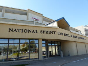
February 2, 2021. Sprint Cars. https://www.thegazette.com/subject/sports/auto-racing/a-sprint-car-education-20210202
January 14, 2021. Embrace the Outdoors. https://www.thegazette.com/subject/sports/outdoors/embracing-x2014-and-enjoying-x2014-the-cold-outdoors-20210114
-
-
Sunset over Cook Inlet.
-
-
A short ride short to shore.
-
-
A popular sport in Iowa.
*****
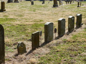
December 20, 2020. Walking Cemeteries. https://www.thegazette.com/subject/sports/outdoors/a-peaceful-outdoor-walking-option-20201221
December 14, 2020 Iowa Meat Lockers: https://www.thegazette.com/subject/sports/outdoors/a-meaty-adventure-20201214
Nov 11, 2020 Iowa’s Inland Seas. https://www.thegazette.com/subject/sports/outdoors/enjoying-iowas-inland-seas-20201111
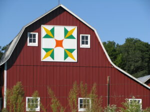
Oct 11, 2020. Barn Quilts. https://www.thegazette.com/article/barn-quilts-offer-brighten-up-the-countryside/
Sept 27, 2020: New Life to Dead Trees. https://www.thegazette.com/subject/sports/outdoors/dead-trees-give-life-20200927
September 20, 2020: Walk Outside Safely. https://www.thegazette.com/subject/sports/outdoors/get-outside-and-walk-but-stay-safe-20200920
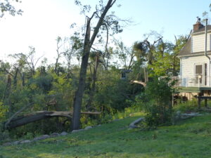
September 9, 2020: Rebirth Amid the Rubble https://www.thegazette.com/subject/sports/outdoors/a-rebirth-among-the-rubble-of-trees-20200906
August 22, 2020: Iowa’s National Parks. https://www.thegazette.com/subject/sports/outdoors/iowa-national-parks-guide-effigy-hoover-20200822
July 27, 2020: County Parks. https://www.thegazette.com/subject/sports/outdoors/take-advantage-of-iowas-county-gems-20200727
July 11, 2020: Tenting. https://www.thegazette.com/subject/sports/outdoors/why-rv-live-isnt-for-these-senior-tent-campers-20200711
June 26, 2020: Bear Sightings in Iowa: https://www.thegazette.com/subject/sports/outdoors/why-rv-live-isnt-for-these-senior-tent-campers-20200711
April 12, 2020” Walk on Wilder side. https://www.thegazette.com/subject/sports/recreation/take-a-walk-on-the-wilder-side-20200412
-
-
Iowa’s Barn Quilt Trails are fun to take.
-
-
Some Union Some Confederates
-
-
Felled trees.
by Winding Pathways | Oct 3, 2024 | Travel/Columns
Camping! Glamping! What’s the difference?
There are some similarities, but a world of difference between the two.
Camping
On a September 2024 drive across Nebraska Route 2 we overnighted in our small tent in the Bessey area of the Nebraska National Forest. Out of the trunk, we hauled our sleeping bags and pads, tent, camp stove, dehydrated food, and lantern. Soon camp was set up. As daylight dimmed, we cooked dinner on a picnic table near our tent. We were CAMPING.
Marion dropped Rich off in Lincoln the next day and continued home. Rich and Cedar Rapids friend, Kurt, joined a group of bicyclists on a multi-day ride on two Nebraska trails.
Glamping
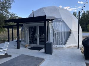
Three days after camping in the national forest, Rich and Kurt carried their small suitcases into a “tent” at Ashland Glamping between Lincoln and Omaha. Their “tent” was a large luxurious geodesic dome that included a full kitchen, a bedroom downstairs with another in the loft, a patio overlooking a small lake, and a restroom and shower. There was nothing to set up. It was comfortable and ready for a pleasant and comfortable stay. They were GLAMPING.
Glamping is a somewhat new word that means glamorous camping. It is fun and far closer to overnighting in a full-service hotel than a rustic campsite. Glamping locations worldwide could include lodging in a tree house, yurt, or amazing cabin. Staying in one is likely costly but is a unique and fun experience.
-

-
Full kitchen and amenities in the dome
-
-
Choose from one of several options.
-

-
Stylish camping.
Find Glamping Sites
Click for a way to find a glamping location. Here is Ashland Glamping’s website.
It’s just off Interstate 80 in Eastern Nebraska and is a quick drive to either Lincoln or Omaha.
by Winding Pathways | Jul 25, 2024 | Nature, Travel/Columns, Water Resources
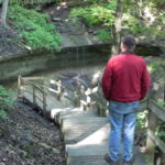
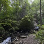
Tumbling waters
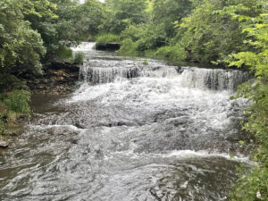
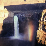
There it is! A Waterfall. There’s a second. Wow, just upstream is a third. Three waterfalls in one Iowa stretch of stream! How can that be in such a flat state?
Waterfalls bring mental images of water tumbling down steep hillsides where it plunges hundreds of feet downward. We’ve marveled at tall falls in many states including Hawaii, Nebraska, Washington, Indiana, Minnesota, New Hampshire, and New Jersey. But Rich had discovered the waterfall trio in an unexpected state – Iowa – and in an equally unexpected part of the state.
-
-
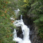
Water tumbles through a narrow cataract.
-
-
Indiana surprise
-
-
North Shore Falls
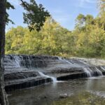
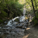
Briggs Woods County Park Delight
Amid north central Iowa’s vast level corn and bean fields he discovered the three cascades after a short hike near Webster City. More than rushing water caught his eyes. Fish were trying to leap up the rushing torrent. “It brought back memories of salmon leaping Brooks Falls in Alaska. These were small fish of an unknown species. Watching them was great fun,” he said. The three falls are close together in Hamilton County’s Briggs Woods Park and all it takes to enjoy them is a short hike on an easy trail.
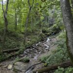
Driftless Area
Iowa isn’t flat. Mostly it’s rolling terrain, but the state’s northeast corner features downright steep slopes. It’s the Driftless area, where most of Iowa’s falls gurgle and tumble down into clear running trout streams.
Touring Iowa’s Waterfalls
Seeing the Briggs Woods falls gave us a waterfall bug, so a few weeks later we drove north from our Cedar Rapids home. A region of Karst topography, the Driftless boasts dozens of clear water trout streams and several impressive falls.
-
-
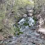
Karst topography helps create waterfalls.
-
-
Bridal veil falls, at Pikes Peak
Decorah Area
Decorah is Iowa’s waterfall epicenter. Twin Springs bubbles quietly from the ground and flows down past a campground. Siewer’s and Dunnings Springs hurl an impressive amount of cool clear water over rocks close to downtown. (Note, the travel Iowa site uses an apostrophe (‘) for Siewer’s Spring but not for Dunnings). It’s easy to park close to all of these. Viewing nearby Malanaphy Springs is worth the mile walk. It’s the best known of several falls that send water to the Upper Iowa River.
-
-
Cooling waters.
-
-
Water tumbles from the ledges
-
-
A popular stop for canoeists on the Upper Iowa River.
-
-
Hike through quiet woods.
Other Waterfalls
Other Waterfalls? Yup. Depending on who you ask and what you consider a waterfall, the Hawkeye state has dozens of them. Many aren’t natural waterfalls. Many are human-made cascades tumbling down a dam spillway, but the ones mentioned above are genuine nature-made falls.
Benefits of Seeking Out Waterfalls
We love falls for their beauty. Visiting them has a side benefit. They are in Iowa’s most beautiful terrain. A waterfall viewing trip gives the opportunity to see these unexpected Iowa sights, hike challenging trails, enjoy local eateries, and overnight in nearby campgrounds or one of the dozens of bed and breakfasts scattered about rural and small-town Iowa.
Where to Find Waterfalls
A helpful resource for finding falls is Travel Iowa – 14 Wonderful Waterfalls in Iowa.
by Winding Pathways | Jul 11, 2024 | Nature, Travel/Columns, Wonderment
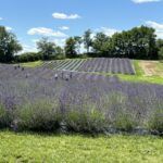
Winding Pathways is near the edge of town, making it easy to drive into the country and enjoy rural views. Mostly our car traverses Iowa’s abundant corn and soybean fields, but two recent trips gave exceptional views of different vegetation that bloomed in bright lavender under the June sun.
The Lavender Farm
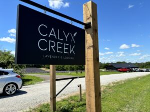
Entry to Calyx Creek
One recent June afternoon as we drove through conventional crops an amazing and delightful view appeared. Shades of purple and stunning white blanketed the undulating land accenting the deep green of cultivated crops. We had discovered Calyx Creek Lavender and Lodging a few miles west of North Liberty, Iowa. Rows of lavender in various stages of growth surrounded us as we entered the main building to find various products made of this unusual plant.
The warm, calming fragrance of the oils of this subtle herb wafted through the shop. Dried bunches hung from racks. Informational signs in front of gleaming machines shared highlights of the distillation process. Soaps, oils, candles, carpet freshener, lavender-infused stuffies and slippers, beverages, and tasty treats beckoned visitors to sample and buy. A lemonade mix was a hit among patrons on this warm summer day. “It smells so good inside, and this lemonade is super!” commented one man, cupping the cool drink in his hands.
-

-
An array of products awaits.
-

-
Slushys are popular.
Tours and Lodging
Part of the experience includes tours, opportunities to harvest and enjoy in your own home, and overnight lodging!
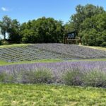
We walked among fields of blooming lavender to two of the several cabins available for rent. The two, built on pedestals, are well-equipped. All the lodgings offer a chance to “get away” while being close to nature. We climbed the stairs, sat on the small cabin’s deck, and took in the rural views of expansive fields of lavender. Peace flowed through us.
-
-
Strolling through lavender fields
-
-
Peaceful overnights
Calyx Creek Lavender and Lodging is a fun place to visit, especially during the early summer blooming time. More information at: Calyx Creek LLC, 1722 255th St. NW, Oxford, IA 52322.
Phone: (319) 900-5992
Where Does Lavender Originate?
Lavender is native to the Mediterranean Region of southern Europe and Northern Africa. It has so many uses that it has been planted around the world. It has become problematic in Australia but is a valued product in North America. Lavender has a long, documented, and storied history with applications for improved health, reducing anxiety, moderating the effects of bug bites and burns, and as an antiseptic/anti-inflammatory agent. The latter is useful in the flu season. Gardeners can grow lavender at home. A helpful resource on how to grow it is at Garden Design.
More Rural Views
The fields of lavender at Calyx Creek are carefully groomed, providing a contrast to our discovery the next day. Secondary roads stairstep through Iowa, replete with rural views of corn, beans, oats, cattle, and goats. We were making our way to a reconstructed prairie south of Waterloo, Iowa
The Irvine Prairie

A happy duo.
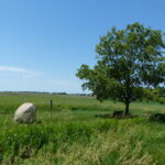
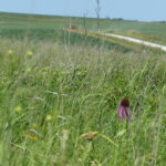
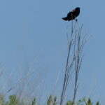
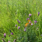
That day Cathy Irvine led us through her prairie dotted with pale purple coneflowers, purple prairie clover, and blooms of different hues. Common yellowthroats serenaded us as red-winged blackbirds winged around this amazing place.
We admired the beauty of one of Iowa’s largest reconstructed prairies and were humbled to have Cathy Irvine share part of her day with us. Some people are so inspiring. She’s one.
After years of conventional farming, her vision took her land in a different direction. She’d turn the clock back and restore her land to how it looked and functioned before the first plow turned the original prairie into row crops. She didn’t do this on a whim. For decades Cathy had thought about, researched, attended programs on, and connected with experts on prairies. She knew that reconstructing the native habitat with its diverse plants and animals was right to do.
-
-
Glacial boulders are part of the landscape.
-
-
Contrast
Collaboration
Working with the Iowa Natural Heritage Foundation and the University of Northern Iowa Tallgrass Prairie Center she placed much of her farm in conservation easement and collaborated on restoring it to its native vegetation in honor of her late husband, David. Being in a conservation easement means that it will remain a wild and gorgeous prairie forever, no matter who might own the land in the future.
Iowa’s Rich Heritage
Iowa’s original prairie hosted upwards of 300 plant species on each acre that agriculture transformed into vast monocultures of soybeans and corn. Cathy’s land was in row crops until she decided to give her property to the Tallgrass Prairie Center under a conservation easement. Starting in 2018 the Prairie Center began planting upwards of 100 native species an acre and followed it up with prescribed burning, weeding, and even plugging in more native species.
Cathy, the Tallgrass Prairie Center, and the Iowa Natural Heritage Foundation welcome visitors to experience what much of Iowa once looked like. It’s a place to enjoy dancing prairie grasses and forbs on a breezy summer day, listen to birds trilling across the expanse, watch butterflies forage on blooms, and be inspired by the quiet beauty resulting from a transformation springing from Cathy’s vision and cooperative effort.
The Prairie is located at 1173 55th Street, Dysart, Iowa. Several mowed trails radiate outward from a small parking lot. A bench nestled under a spreading tree offers shade and a place to reflect.
-
-
Calling out territory
-
-
colorful forbs
-
-
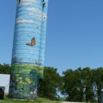
Colorful silo
Best Times To Enjoy Prairie Flowers
Prairie flowers bloom throughout the growing season but during midsummer’s heat, the colors are most amazing. However, the prairie is magical in any season. We enjoy our small reconstructed prairies through all seasons and especially in the summer months.
The Lavender Farm meticulously cultivates a useful plant not native to Iowa and the Irvine Prairie carefully stewards a rewilded prairie. Both are gorgeous.
For more information, visit the Tallgrass Prairie Center and the Iowa Natural Heritage Foundation websites.
The Color Purple
Our eyes had the good fortune to view purple lavender one day and purple prairie flowers the next, but purple is a tricky color, at least for some people. Like around 10% of men and boys, Rich isn’t able to see it or see it as folks with normal color vision can. “Red and shades of red are hard for me to see. Purple is nearly impossible. It seems odd but I can see the color but know it looks very different to me than to most folks. If someone asks me what purple looks like I have to say, I’m not sure since I can’t really see it,” he said. “Fortunately I can see blue and yellow prairie blooms and magnificent butterfly milkweed flowers that seem to glow a bright orange,” he added.
Winding Pathways encourages readers to take in any of their native habitat to appreciate our green island home – Earth.